Specific and general terms useful in Bonner County, Idaho
A
A/F 10. An Agricultural/Forest zoning designation in Bonner County that requires minimum lot sizes of 10 acres. This is less restrictive than A/F 20, but still may be applied to land unsuitable for other zoning, due to slopes, location, access to services, and more. See Bonner County’s Zoning District information here.
A/F 20. An Agricultural/Forestry zoning designation in Bonner County that requires minimum lot sizes of 20 acres. This zoning designates areas for large-lot farm and forest use to preserve rural character, protect forestry, and allow for agricultural activities like livestock and timber production. This zoning designation often features prime agricultural soils, steeper slopes, or limited access, contrasting with A/F-10, which is for less prime agricultural or forest land. See Bonner County’s Zoning District information here.
AV/ Alpine Village. In Bonner County, the Alpine Village zoning district was created to accommodate recreational development in high-elevation communities such as Schweitzer ski resort. The Alpine Village zone allows a range of housing types and uses that are complementary to recreational and residential uses. See Bonner County’s Zoning District information here.
Air Rights. The right granted by a property owner to a buyer to use space above an existing right-of-way or building, usually for development. If you own the air rights above a building, that means the building owner may not build upwards, so air rights may be used to preserve views.
Appeal. When someone believes a land use decision was made in error, an appeal may be filed so that a higher (or different) decision-making body can review the case.
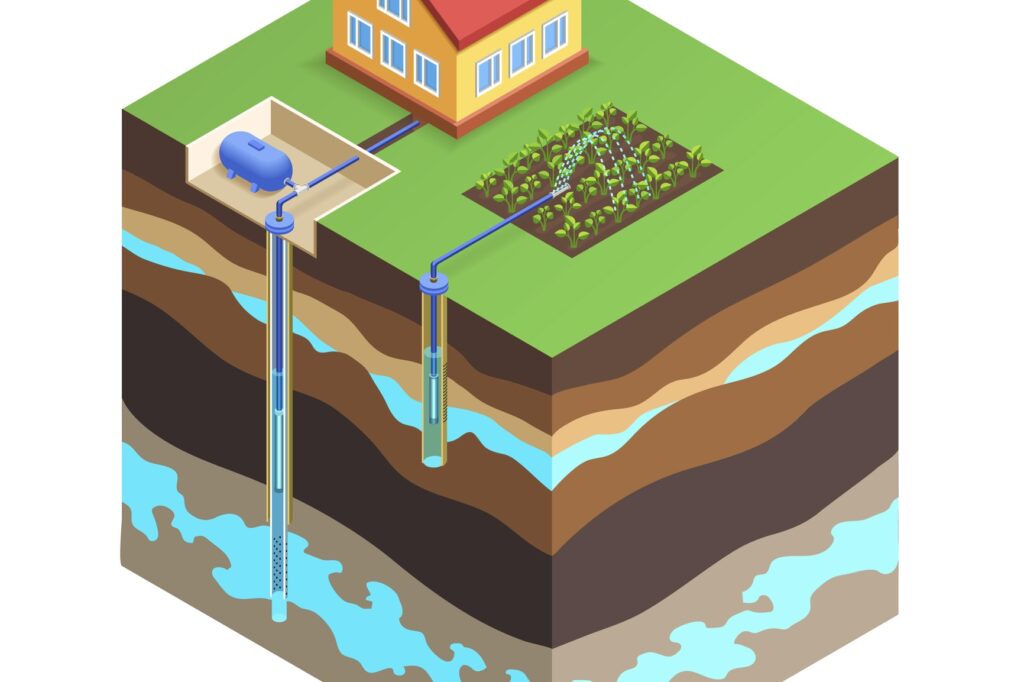
Aquifer. An underground, water-bearing layer of earth, porous rock, sand, or gravel, through which water can seep or be held in natural storage. Aquifers typically hold sufficient water to be used as a water supply. Private wells tap into aquifers, and if too many wells are drilled into certain aquifers, all the wells will suffer. Water rights can regulate wells based on how much water is available both underground and on the surface.
Arable. Adjective describing land that can be used for farming.
Arterial. In land use, a main roadway that provides access to the highway system. Arterials are medium-speed and medium-capacity roads. Access to community arterials should be provided at collector roads and local streets, but direct access from parcels to existing arterials is also common.
B
Berm. A mound of earth or concrete designed to shield specific areas, such as parking areas. Berms are often used to minimize water run-off.
Bicycle-friendly. Community design and infrastructure that support cycling as a regular mode of travel, as well as recreation. Bicycle racks on streets or by public buildings help make a town more bicycle-friendly, as does the position and aesthetics of bicycle paths relative to roads and their surroundings. Safety features such as lighting and protection from on-road vehicles may help people become more comfortable about travelling by bicycle.
Buffer zone. An area of land separating two distinct land uses that softens the effects of one land use on the other. This could be in the form of additional use or height restrictions, such as a rule preventing a three-story commercial building next to a residential district. The term can also describe any zone that separates two different zones, such as a multifamily housing zone between single-family housing and commercial uses.
Building code. Standards adopted by the state, county, or city governing construction, occupancy, and other use of buildings. Outside the cities, “Bonner County has not had any adopted building codes since 1997. This means the structural integrity of a building is not regulated and there is not a ‘one-stop-shop’ to obtain all permits required for building. However, the location and use of development is regulated via permits and other applications to ensure conformance with the standards of Bonner County’s local ordinance.” Link to source: https://www.bonnercountyid.gov/frequently-asked-questions-1
Building coverage. The amount of land covered by buildings, usually expressed as a percentage.
Built environment. Buildings, roads, parks, and all other developments. The built environment forms the physical character of a community.
Buyer beware. “Buyer beware” in Idaho means consumers purchasing items — particularly big-ticket items like real estate — must do their own due diligence because sellers aren’t always required to disclose everything. However, Idaho’s Consumer Protection Act prohibits outright fraud, scams, and deceptive practices like false advertising, allowing buyers recourse if sellers make specific misrepresentations or omit key known issues. Bonner County claims that this means properties “may have been unlawfully split or developed and sellers/realtors are not required to disclose this information,” although this would arguably be deceptive and contrary to Idaho law.
C
Certificate of Occupancy. An official certification that a building conforms to the provisions of the zoning and building codes, and therefore may be used or occupied. Within the City of Sandpoint, for example, a structure cannot legally be occupied without a certificate of occupancy.
City Council. A city’s legislative body. An elected city council is responsible for enacting ordinances, establishing city policy, hiring some city officials, and so on. The council adopts the comprehensive plan, zoning, and subdivision ordinances.
C/ Commercial. A land use classification intended for businesses that sell goods or services. Commercial zones may regulate the placement of certain types of facilities, such as liquor stores or gun ranges. In Bonner County, commercial zoning allows a wide range of small-to-medium sized retail, professional, governmental and personal services. It also allows for mixed-use buildings (like housing over office or retail) and a range of housing types, including apartments and mobile home parks where sufficient services are provided. See Bonner County’s Zoning District information here.
Common open space. Land within a development that is designed and intended for the common use of the residents of the development.
Community planning. Community planning is about designing urban and rural areas to meet the needs of a community. Cities and counties always change over time, and planning ensures that changes are positive and strategic. Without the community being involved in planning, city and county changes may only favor developers or a few specific people. See more here.
Compatibility. In land use, different activities that can be located near each other in harmony and without conflict. Permitted and conditionally permitted uses in any zoning district should achieve compatibility. Compatibility considers things like dwelling units per acre; traffic generated; and environmental effects like noise, vibration, glare, air pollution, or radiation. A discotech or mining operation, for example, would not be compatible with a residential zone.
Comprehensive plan. A comprehensive plan is a long-term strategic document guiding a city or county’s future development, growth, and preservation. It covers land use, transportation, and public services into a unified vision with goals, policies, and strategies for current and future generations. Comprehensive plans are often mandated by state law and developed with community input. They act as a legal foundation for zoning, development approvals, and policy decisions, ensuring coordinated and thoughtful growth. Read more here.
Conditional Use Permit (CUP). A discretionary permit to allow a use that may or may not be allowable under the zoning code. If approval is granted, the developer often has to meet certain conditions to harmonize the project with its surroundings. Each application is considered on its individual merits. CUPs require a public hearing and, if approval is granted, are often subject to the fulfillment of certain conditions by the developer. Approval of a CUP is not a change in zoning. Mining gravel, for example, requires a CUP.
Consent agenda. A tool used by governing bodies such as the Bonner County Commissioners. Items on the consent agenda are not formally open to public comment. The idea is to allow many “small” items to be approved with one vote, streamlining meetings by saving time and focusing discussion on more critical issues. Any member of the Commission is still able to pull an item out for individual debate. It has been a matter of controversy that certain land use decisions in Bonner County were on the consent agenda rather than being subject to a public hearing.
Conservation easement. A conservation easement is a voluntary agreement between a landowner and an organization like a land trust that protects land from development in order to maintain important natural qualities. The easement transfers some degree of the development rights to the land trust, after which they are effectively retired. The underlying owner of the land can continue to use the land according to the terms of the easement. In Idaho, conservation easements may offer tax benefits to the land owner, and are intended to preserve natural resources.
Covenants, Conditions, and Restrictions (CC&Rs). A term used to describe limitations that may be placed on property and its use, and which usually are made a condition of holding title or lease. They are intended to preserve the physical nature and character of the development. They are most commonly used in subdivisions to restrict the use of all individual lots to a certain type of use (like single-family units), but may also be used to guarantee views, for example.
Critical Groundwater Area (CGWA). A formally designated region where groundwater is being withdrawn faster than it’s replenished, leading to shortages, declining water levels, or potential harm to existing users and ecosystems, prompting state agencies like Idaho Department of Water Resources (IDWR) to regulate pumping to ensure sustainable supply.
D
Deed restriction. A private legal restriction on the use of land recorded in the deed. The restriction burdens or limits the use of the property in some way. CC&Rs and easements are examples of deed restrictions.
Density. The amount of development per acre permitted on a parcel. Zoning usually regulates density, although in Bonner County, available services (water and sewer) play a major role in determining allowable density. See the Bonner County density tables here.
Development fee. A charge imposed on developers to pay for the costs to the community of providing services to a new development. Some common examples are (1) impact fees related to funding public improvements such as roads; (2) connection fees to cover the cost of installing public services like sewer to the development; (3) application fees for the administrative costs of reviewing and hearing development proposals.
E
Easement. The right to use property owned by someone else for specific purposes, or to gain access to another property. For example, utility companies often have easements to maintain utilities, and in rural areas, driveway and road easements are not uncommon.
Encroachment. Any protrusion into a right-of-way, public space, or adjacent property, whether on the land or above it. In Bonner County, encroachments require an encroachment permit.
Endangered species. Animal or plant species designated as endangered under federal or state law, whose prospects for survival are in immediate jeopardy. If a property is located within or next to endangered species habitat, it may impact how the property can be developed. There are a number of threatened species in Bonner County, and removing them (outside of imminent harm) can be illegal even on your own property.

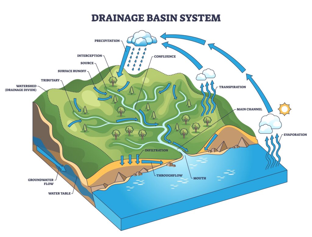
Erosion. The loss of land to natural causes. The loss of rock and soil debris can be caused by wind, rain, or running water. In Bonner County, erosion is common on the shoreline of streams and rivers, and can also occur in the floodplain.
F
F 40. A forestry zoning designation with minimum lot sizes of 40 acres. According to Bonner County code, “The Forestry district is established to preserve the forest land base; to conserve and protect the long-term productivity of forest lands; and to restrict uses unrelated to or incompatible with forestry.” Link is here to Bonner County’s Title 12, which describes this zoning designation in more detail.
Floodplain. A floodplain is an area at risk of flooding if too much extra water is introduced, usually via rain, melting snow, or both. Floodplains are relatively level, are typically adjacent to a body of water, and can stretch from the banks of a river or lake to the base of the enclosing valley. As Bonner County notes, “Many properties along Bonner County’s numerous lakes, rivers and streams include areas located with special flood hazard areas (‘floodplains’).” Building in a floodplain is regulated due to the danger of flooding.
G
Grandfathered. In land use, to “grandfather” something means to exempt it from new regulations, laws, or requirements. For example, grandfathering allows a parcel to continue operating under old rules, protecting it from changes that apply to future, new, or modified code.
Groundwater recharge. When water, such as rain or snow, percolates through permeable soils into aquifers. Without groundwater recharge, wells can run dry. If groundwater recharge is too slow, due to the type of soil, lack of rain, or something else, aquifers can dry up.
Groundwater. Water under the earth’s surface, usually meaning aquifers capable of supplying wells and springs.
H
Hazardous material. A substance capable of posing an unreasonable risk to health, safety, or property. If disposed of incorrectly, hazardous material can seep into groundwater and surface water and contaminate surrounding areas. Raw sewage is a hazardous material, which is why sewer systems are regulated in Bonner County.
I
I/ Industrial. A land use classification sometimes divided into “heavy industrial” uses, like construction yards, quarries, and factories; and “light industrial” uses, like research and warehousing. In Bonner County, there is only one Industrial zoning district, intended for “industrial economic development and employment opportunities.” Due to how much traffic these zones generate, “these areas require primary transportation routes, urban-like water and sewer services, fire and police services and consideration given to the potential public transportation access,” according to Bonner County code. See Bonner County’s Zoning District information here.
Impervious surface. A surface that water cannot penetrate, such as any paved area. The amount of impervious surface increases with development, and establishes the need for drainage to carry the increased runoff. Impervious surfaces without proper drainage increase the likelihood of flooding. Next to bodies of water, they can carry contaminants and runoff directly into the water, where they can spread to neighboring properties, public beaches, and aquatic wildlife. Because impervious surfaces change the ecosystem, they increase the spread of invasive species such as Eurasian milfoil in Bonner County waterways.
Infrastructure. Public services and facilities like sewage disposal, water supply, roads, bicycle paths, and sidewalks. Any city, county, or state, needs infrastructure to function properly and maintain safety.
J-K-L
LLUPA. Stands for Idaho’s Local Land Use Planning Act. LLUPA, sometimes called ILLUPA, was adopted in 1975 and has been subject to piecemeal amendment with minor “once-over” in 2000 (Idaho Code §67-6503). Every city and county must participate in carrying out the planning guidelines as set forth in ILLUPA, though there are no specific sanctions in the legislation for failure to comply.
Land use. Land use describes how humans use land for activities — for instance, agriculture, housing, commerce, recreation, or conservation. Land use focuses on purpose. Land use planning is often enforced through zoning (like residential or commercial zoning) and manages these uses to balance development with the protection of neighbors, natural resources, and available services.
Land use designation. A land use designation is a comprehensive planning tool that outlines the long-term, permissible future use of land, such as residential, commercial, industrial, or agricultural, as defined in a city or county’s comprehensive plan. It differs from zoning, which dictates current, specific, and legal regulations. The zoning district may overlap directly with specific land use designations; for example, both may be called commercial. Other times, different zones can occur in one land use designation. For example, a “rural residential” land use designation could include zoning for both five-acre and ten-acre parcels.
Lien. A claim on assets, especially property, for the payment of taxes or other outstanding debt.
Light pollution. Light pollution is excessive, misdirected, or misused artificial light at night. It creates skyglow and glare, obscuring stars for 80% of Americans. This pollution disrupts ecosystems, can harm wildlife and negatively affect human health, and wastes energy.

Lot. A piece of land with fixed boundaries that are designated on a survey map. Any conforming lot size must meet the requirements of the zoning district, and if it is supposed to be accessible, must front a public road or an approved private road.
Lot coverage. The amount of a lot that is covered by buildings and impervious surfaces, usually expressed as a percentage.
Lot line adjustment. The adjustment of a lot line between two or more existing parcels where land taken from one parcel is added to an adjacent parcel and where a greater number of parcels than originally existed are not thereby created. A parcel created through a lot line adjustment may be illegal. Lot line adjustments must also comply with zoning design standards.
M
Metes and bounds. A system of identifying land using measures (metes) and direction (bounds) from a point of reference like the corner of intersecting streets or some other permanent fixture.
Microclimate. The climate of a small, distinct area, such as a city street, a neighborhood, or a building’s courtyard. Microclimates can be created and altered through landscaping and architecture. A sidewalk with a bare south-facing concrete wall will create a different microclimate than a sidewalk with mature trees, particularly in July.
Mixed-use. Properties or neighborhoods that mix uses such as offices, restaurants, and residential. Mixed-use zoning often places constraints on the types of business that can be conducted within the zone, and may prohibit liquor stores, for example.
Moratorium. A tool that temporarily freezes some type of development for a set amount of time. A moratorium may be used when the governing body realizes that code needs to be fixed, in order to give them time to fix it.
Municipal services. Services traditionally provided by local agencies, including water and sewer, roads, parks, schools, and police and fire protection.
N
NIMBY. An acronym for Not In My Back Yard. A pejorative term used to characterize opponents of development projects, with the implication that the opposition is based on personal self-interest as opposed to the interests of the larger community.
Nonconforming use. A use that was valid when brought into existence, but by subsequent regulation becomes no longer conforming. These are legal and the use is understood to be grandfathered in. Nonconforming lots, for example, may be smaller than what current zoning requires, but are still usable lots.
Noncompliant. A structure, lot, or business that was created outside the limits of the law. Noncompliant structures and uses are illegal in Bonner County. If an owner builds a noncompliant structure, or operates a noncompliant business, they can face serious penalties.
O
Off-grid. A term used to describe a system or home that runs independent of a conventional public utility grid. Off-grid homes are not uncommon in Northern Idaho, and usually operate with solar power, wells, water storage tanks, private septic, wood heat, or propane. Off-grid homes can pose challenges to firefighting, particularly if large amounts of propane or diesel fuel are stored on the property.
Ordinance. A regulation adopted by a public agency, usually a city or county.
P
Parcel. Any number of lots in single ownership or under single control, usually considered a unit for purposes of development.
Pedestrian-friendly. Any area that deliberately promotes pedestrian access. Pedestrian-friendly planning supports stores, offices, residences, schools, and recreational areas being within walking distance of each other. Such areas also often feature narrow streets, trees, awnings, covered transit shelters, benches, sidewalks on both sides of the roadway, and safe street crossings.
Permitting. A formal process of providing legal permission to do something. In unincorporated Bonner County, certain permits are required for new buildings, even though there is no specific building code. Not obtaining a permit, such as a building location permit or a septic system permit, will result in noncompliance and penalties.
Planned Unit Development (PUD). A flexible zoning tool allowing developers to create customized master-planned communities with mixed uses (residential, commercial, recreational) or creative layouts. These are established during the process of considering proposals and adopted by ordinance upon project approval.
Planning. In land use, planning means organizing and managing land development. The goal of land use planning is to ensure that a community’s quality of life, economic vitality, infrastructure, public safety and environmental health are protected and improved over time. Planning boards or staff are tasked with balancing community needs, economic growth, and natural resource protection. Planning is supposed to ensure sustainable and orderly growth for the future.
Plat map. A map of a lot, parcel, subdivision, or development area where the lines of each land division are shown by accurate distances and bearings. A plat map is necessary for new development to make sure that buildings fall within setbacks, for example.
Prime farmland. Land that has the best combination of physical and chemical characteristics for the production of crops as determined by the U.S. Department of Agriculture.
Private road. Privately owned roadway for motor vehicle access. Bonner County does not maintain private roads. Any plowing, road, or bridge construction is typically split between owners of the properties along the private road. Private roads may not be accessible to the fire department or ambulance, depending on how they are built or maintained.
Property rights. Property rights in the context of real estate establish how the owner can use, control, and transfer a property. These refer to the five core rights of property ownership: possession, control, exclusion, enjoyment, and disposition. Property rights are never absolute, meaning that other laws still apply — whether it be a law against murder or a law against dumping nuclear waste.
Public hearing. A formal, open meeting where government bodies or agencies gather testimony and opinions from the public about a proposed action or issue, like zoning changes or new projects, creating a record for decision-makers and ensuring transparency in governance. These hearings allow citizens to speak, provide evidence, and voice support or opposition, often with time limits. The governing body should then make a final decision based on all presented information, including staff reports and applicant input. Many land use changes in Bonner County require public hearings, but not all do.
Q-R
R 5. A rural residential zoning designation in Bonner County with a minimum lot size of 5 acres. Rural districts are established to allow low-density residential uses that are compatible with rural activities. See Bonner County’s Zoning District information here.
R 10. A rural residential zoning designation in Bonner County with a minimum lot size of 10 acres. Rural districts are established to allow low-density residential uses that are compatible with rural activities. The larger minimum lot size is due to things like slopes greater than 30%, animal habitat, or remote locations away from main roads. See Bonner County’s Zoning District information here.
RSC/ Rural Service Center. A Bonner County zoning designation allowing for certain types of services in rural zones. See Bonner County’s Zoning District information here.
R/ Recreation. A Bonner County zoning designation that allows recreational activities. The zone requires adequate roads, water and sewer services, and fire services. See Bonner County’s Zoning District information here.
Residential. Land designated for dwelling units or residences. May be improved or vacant land.
Residential Multi-Family, or multi-family zoning. A type of housing that has several residential units on a single parcel, such as condominiums and apartments. The City of Sandpoint has a specific zoning designation for this, but unincorporated Bonner County includes multi-family zoning in Commercial districts. In Bonner County, adding one accessory dwelling unit (as defined by the county) does not require multi-family zoning.
Riparian rights. The right of landowners to make use of the river, lake, or stream bordering their property. Any encroachments into a public waterway, however, requires an encroachment permit from the Idaho Department of Lands.
Runoff. Water from rain or snow that is not absorbed into the ground, but instead flows into waterways such as the lake. Runoff can pick up fertilizer, oil, pesticides, and other pollutants, which can make the lake, stream or river unhealthy for human recreation and encourages invasive species.
S
S/ Suburban. A land use classification used for the development of residential uses located on the edges of the incorporated cities or other developed areas, where urban sewer and water services are either available or have the potential to become available in the near future. Access to primary transportation routes and a system of hard-surfaced roads are expected. See Bonner County’s Zoning District information here.
Septic system. A sewage treatment system. The most traditional type of septic system includes a settling tank through which liquid sewage flows, and in which solid sewage settles and is decomposed by bacteria, and includes both a tank and a drainfield, which can be quite large. Read more here. Private septic systems are common in Bonner County where urban sewer systems are not available. In Idaho, septic systems require a permit from the Panhandle Health District.
Setback. In land use, a setback is the minimum distance that a building or other structure must be set back from a property line, street, shoreline, floodplain, or any other place which is deemed to need protection. Local governments create setbacks through ordinances, zoning restrictions, and sometimes building codes, usually for safety, privacy, and environmental protection. Setbacks along state, provincial, or federal highways may also be set in the laws of the state, province, or federal government.
Site plan review. The process in which local officials review the site plans of a development to make sure they meet the purposes and standards of the zone, provide for necessary public facilities like streets, and protect adjacent properties.
Smart growth. A broad concept that describes development that best serves the economic, environmental, and social needs of communities. There are ten principles of smart growth: (1) Mix land uses (2) Take advantage of compact building design (3) Create a range of housing opportunities and choices (4) Create walkable neighborhoods (5) Foster distinctive, attractive communities with a strong sense of place (6) Preserve open space, farmland, natural beauty, and critical environmental areas (7) Strengthen and direct development toward existing communities rather than creating sprawl (8) Provide a variety of transportation choices (9) Make development decisions predictable, fair, and cost effective (10) Encourage community and stakeholder collaboration in development decisions.
Spot zoning. The awarding of a use classification to an isolated parcel of land that is incompatible with the uses of the surrounding area. A special circumstance like historical value, environmental importance, or scenic value could justify special zoning for a small area. Spot zoning can often be abused to favor a particular owner.
Sprawl. In land use, the spreading of a city and its suburbs over rural land at the fringe of an urban area. Characteristics of sprawl include single-use zoning that often separates housing from jobs and commercial centers, and low-density land use focused on single-family homes. Sprawl usually includes extensive land devoted to parking and favors roads that are not pedestrian-friendly. Avoiding sprawl requires long-term planning in the areas surrounding cities.
Subdivision. The division of a single piece of land into defined lots, which can be separately sold, and which can be altered or developed. Any land division of four or more lots is subject to the Idaho Local Land Use Planning Act. Breaking up any lot into smaller lots could be called a subdivision, but within the Bonner County code, a subdivision is a specific kind of land split.
Sustainable development. A pattern of development that meets the needs of the present without compromising the ability of future generations to meet their own needs.
T
Title 12. Title 12 of the Bonner County Revised Code governs land use regulations. It covers zoning, subdivisions, permits and more for areas outside Bonner County’s cities. Its goal is to balance development with public welfare, environment, and property rights.
Trip generation. A trip generation report calculates how many additional trips people would take in cars, walking or bicycling. Trip generation is the basis for estimating how a road would be impacted by a new development, for example.
U
Unincorporated. In land use, this refers to areas outside cities. A city is incorporated, and the areas outside the city are unincorporated. Cities have jurisdiction over the development within the city, whereas unincorporated areas are overseen by the county.
Urban services. Urban services refers to the services provided by an urban district. Namely, sanitary sewers; water; fire protection; parks and recreation; and streets, roads and transportation.
V
Variance. Relief from certain provisions of a zoning ordinance granted to a property owner when compliance would result in particular hardship not of the landowner’s making. Theoretically, this is distinguished from a mere inconvenience or a desire to make more money. For example, a variance may be granted to reduce setback requirements, if there is a steep slope on one side of the property.
W
Watershed. The total area above a watercourse — such as a stream — that contributes water to its flow. A mountain face, for example, may be within the watershed of a creek, since water runs down the mountain into the creek. Anything happening in the watershed can have downstream consequences. Watersheds direct rain and snow into lower bodies of water:
Water rights. The legal entitlement to use water from a specific source, granted by states. This is not ownership of the water itself, because in many places, all water is public. Water rights are considered property rights, and in Idaho, they depend on who got there first. A new well may actually interfere with someone’s established water rights, even someone far downstream of the new well.
Wetlands. Transitional areas where land is covered by or saturated with water, creating unique ecosystems like marshes, swamps, and bogs. They are crucial for biodiversity, flood control, and water purification, and act as natural buffers between aquatic and terrestrial environments. They also naturally help prevent and curb wildfire. Characterized by certain types of soils and specialized hydrophytes (water-loving plants), these areas support diverse species, filter pollutants, absorb floodwaters, and provide habitats, functioning as essential natural buffer systems worldwide. Wetlands provide challenges for some types of land use, as they are not suited for traditional sewage systems or wells, and are prone to flooding.
Wildland-Urban Interface (WUI). The transition zone between unoccupied land and human development, where human structures intermingle with undeveloped wildland or vegetative fuels. It is a high-risk area for wildfires, so development in the WUI requires fire-safe planning. Most of Bonner County falls within the WUI.
X-Y
YIMBY. An acronym that stands for Yes In My Back Yard. Being pro-development, including on property next door to the individual who is pro-development.
Z
Zoning. Zoning rules let landowners know what they can build on their land. These rules prevent problems like having loud factories or late-night bars next to homes, or having high-density living in areas that cannot support it. Zoning typically divides land into districts such as residential, commercial, and industrial, and sets development standards like building density and setbacks to ensure that (for example) the roof doesn’t shed snow onto the neighbor’s fence. Zoning should implement a community’s comprehensive plan. Read more here.
Zoning district. A zoning district is a specifically designated geographic area within a municipality, defined by local laws (zoning ordinances) and shown on a zoning map. These districts enforce unique, specific rules for permitted activities, such as residential, commercial, industrial, or agricultural, ensuring orderly growth. See Bonner County’s Zoning District information here.