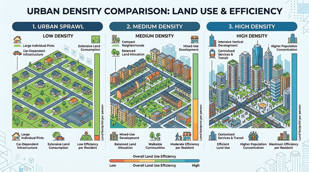
Sprawl is the spread of low-density urban or suburban development outward from an urban center. Apartments are high-density, meaning many people can live on a single acre, for example. Sprawl would be the opposite, with as few as one person living on a single acre. This means that urban areas are more spread-out, less walkable, and more expensive, among other things.
Sprawl dominates current patterns of urban development in the United States, and therefore has become a hot topic. A wide variety of professions —economists, planners, public officials, those interested in public health, developers, geographers, ecologists — have been discussing sprawl since the 1970s. The debate has largely focused on questions such as “what is sprawl?” and “what are the costs of sprawl?”
What is sprawl? Researchers seem to agree that sprawl is one end on a spectrum of development, whose opposite end is compactness.
Some researchers simply define compact development as dense development, or a given area that has a high number of people living in it. What is considered dense varies by community. For some places, such as Sandpoint, a density of at least six to seven people per acre of land might be quite dense, whereas for others, such as Seattle, that rate of occupancy might be considered very low-density.
It turns out, however, that sprawl is defined by factors other than just population density. Sprawl can actually be identified by four prototypes:
1. Leapfrog or Scattered Development
In leapfrog or scattered development, residents and service providers must pass vacant land on their way from one developed use to another. The pattern is characterized by large, vacant tracts of land separating developments.
2. Commercial Strip Development
In classic strip development, the consumer must pass other uses on the way from one store to the next; it is the antithesis of multipurpose travel to an activity center. This pattern is characterized by “strip malls” of stores lined up along a busy, primary road.
3. Large Expanses of Low-Density or Single-Use Development
In low-density, single-use development, everything is far apart due to large private land holdings and segregation of land uses. This pattern is most frequently appears as large residential neighborhoods located far from services such as grocery stores, schools, libraries, and so on.
4. Any development pattern characterized by poor accessibility and lack of open space
Development patterns with poor accessibility frequently have a low number of street intersections per square mile, lack public transit service, and do not feature diverse land uses (such as a grocery store situated within a residential neighborhood). Open space refers to any open piece of land that is undeveloped (has no buildings or other built structures) and is accessible to the public, including schoolyards, vacant lots, public parks, forests, and bodies of water, community gardens, and playgrounds.
The costs of sprawl can be significant. Personal costs include more car miles, for example. Increased public costs include:
- More expensive public services. Sprawling layouts increase the cost of laying and fixing water pipes, electric grids, and sewage lines by 10% to 40% compared to compact areas.
- More road maintenance. Spreading homes out can create a massive, underfunded maintenance backlog for road networks.
- Stretched municipal budgets. Low-density towns often struggle with long-term upkeep because property taxes on single-family homes frequently fail to cover future replacement costs for infrastructure.