Bonner County Story Map
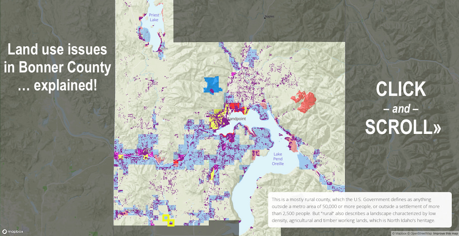
The core land use issues concerning development and ways we might maintain rural values in Bonner County can be complicated. But check this out! We’ve cooked up this Story Map that uses some great visuals to help explain land use planning issues in Bonner County. Projections and data are all from November 2021. Click to the Story Map »
To see an update from November 2023 on how our county has been growing, see our short presentation here and our brief rundown on the problem presented by minor land divisions here.
Ongoing Comprehensive Plan Updates
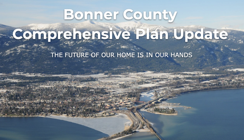
A comprehensive plan is a guiding framework for how the community wants an area to look over the next 10-20 years. Cities and counties all over the country have comprehensive plans. They usually take about a year or more to complete and are done every 5-15 years. Cities have a separate plan from the surrounding county. The main focus for these plans are land use, and attempts to address subjects like public services, transportation, housing, and property rights.
One of the biggest and most important parts of the plan is public engagement. Engagement comes in many different forms, but is central to making sure the plan is well rounded and has input from those who live in city limits, those who live outside it, and various community stakeholders.
Sandpoint’s Comprehensive Plan
The City of Sandpoint has consultants working to gather data and after a period of public comment, are working on a final draft.
As the Sandpoint Reader notes, trees and a concern that the city is not working with neighboring cities are both currently hot-button issues for citizens. The latter issue arose when the city committed to providing water service to the controversial 116-lot Providence Subdivision, which is located in the city of Kootenai’s area of city impact (ACI), which is land that is expected to be annexed by that city in the future.
Sandpoint’s current plan includes a policy under the goal of Resource Conservation that states: “Deny extension of urban services in ACI for low density development.” Low density development is defined as 2 to 4 dwelling units per acre. That language is absent in the new plan.
Bonner County’s Comprehensive Plan
Bonner County has a much different approach, to say the least. Several years ago, the county planning department started 5 subarea committees and some of them did several public workshops/outreaching, while others did not. That is the extent of the public engagement that the County Planning Commission is relying on to “inform” the decisions they are currently making on the Comprehensive Plan.
After attending some of these planning committee meetings, Project 7B members became concerned about the aggressive timeline the commission had adopted as well as the lack of real public engagement. The planning commission adopted a 4-month timeline as opposed to a normal 1+ year timeline that is often adopted by other counties and cities.
Following the adoption of new Goals and Policies for the county land use plan in 2022, the Planning Commission has been doggedly updating each chapter of the plan. At a November 7 2023 meeting, the Planning Commission took public input on their first draft of the Natural Resources chapter of the updated land use plan, receiving comments from Idaho Conservation League and Idaho Department of Fish and Game on improving the sections on water quality, wetlands, fisheries, forests, wildlife, and more.
Unfortunately, these chapters are being developed after the goals and objectives were adopted last year. Project 7B had urged the county to do the goals and objectives second, and for example, this could have mitigated a county objective treating RVs as single family dwellings. However, having accurate information and guidance in the chapters is still important, and must still be considered when the county makes decisions on land use codes and land development decisions.
You can stay up-to-date on the County’s planning activities by following Project 7B on Facebook and Instagram, where we post frequently. Our goal is to inform the public on a variety of land-use topics. Citizens may also reach out to the Bonner County Planning Department, County Commissioners, and the County Planning Committee to express concern. The current Bonner County plan is here.
Exploring Innovative Solutions to the Housing Crisis: Community Land Trust
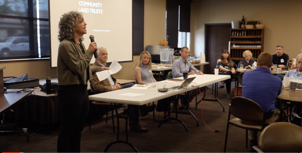
Like many communities in the rural west, Bonner County is experiencing a severe shortage of workforce and affordable housing.
Most local residents have stories of friends or family who can no longer afford to rent, nor to purchase a home at the current market prices. Meanwhile, businesses are hurting for employees who either cannot move here nor remain in the area due to the gap between prevailing wages and the high cost of housing.
Project 7B and Kaniksu Land Trust (KLT) are among organizations in the community searching for solutions. These two coordinated a panel of speakers in June to discuss one potential tool to address this situation: housing provided through collaboration with community land trusts (CLTs). Click here to watch the conversation.
“A Community Conversation: How workforce housing can be delivered through collaboration with community land trusts” was the first topic of what’s hoped to be a series of discussions regarding workforce housing, according to Carol Curtis of Project 7B.
One of the panelists is Michael Brown, an expert on community land trusts. Brown has spent his last 40 years working with Burlington Associates with a focus on establishing and supporting community land trusts. Brown also leads the Headwaters Community Housing Trust, a non-profit that is tackling similar issues in Bozeman, Montana. The group has just unveiled their first CLT project: Bridger View.
Community land trusts are one housing strategy that is being employed in a number of communities facing the same challenges that Bonner County is currently experiencing.
Additional panelists will include KLT Executive Director Katie Cox and Ponderay City Community Development Director Erik Brubaker. The panel will be facilitated by Lisa Gerber of Big Leap Creative. Gerber’s podcast, Breaking Trail, has tackled the subject of growth and affordability in recent episodes.
Following the panel discussion, attendees will be invited to join roundtable discussions to explore the viability of using the community land trust strategy in the Sandpoint area.
This event was made possible through a grant from the Bonner County Human Rights Task Force and with support from the Selkirk Association of Realtors and the Bonner Community Housing Agency.
Watch Land Use Planning 101 in Bonner County
Project 7B has paired with the Gateway and Natural Amenity Region Initiative to give you Planning 101, a webinar for Bonner County. Watch the webinar to learn all about comprehensive plans from Jordan Katcher and Leanne Bernstein. You can also see the summary and notes from the webinar here.
Sandpoint Reader, February 25, 2021
Enjoy a two part feature article written by Project 7B Board Member Susan Drumheller.
Link to part one in Sandpoint Reader here.
Sandpoint Reader, March 4, 2021
Link to part two in Sandpoint Reader here.
Support Project 7B
Thank you for being a Project 7B follower. It’s a lot of work keeping up with area planning, and we’re here to help protect planning principles and support citizen involvement.
Please consider donating to help us continue to keep Bonner County residents informed. You can donate via the PayPal link below, or send a check to Project 7B at PO Box 2365, Sandpoint ID 83864.
Time-lapse Imagery of the Last Quarter Century on Earth
Take a look at this site from TIME magazine http://world.time.com/timelapse/. Choose a location and watch the changes that have occurred from the mid-1980s until 2012 from satellite images strung together. You can look at some of their focus locations such as Las Vegas or the Amazon or you can type in any location such as Bonner County.